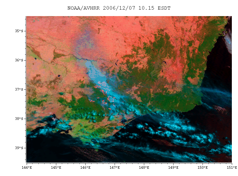
This is a satellite image of the Victorian bushfires from the satellite NOAH/AVHRR at 10.15 am ESDT, on Dec 7 2006 (click on the image to see it full size). It was processed by Edward King from CSIRO’s Division of Marine and Atmospheric Research. The colours indicate green for forest, blue for smoke and cloud, and red for heat of 45 degrees Celsius and above. The squiggly red lines just to the left of centre are the actual fire fronts – amazing!

The fires were started by lightning over a week ago, and there is a lot of worry that in the extreme weather conditions expected this weekend, they will merge into a 100 km front. It’s scary stuff.
This all reminds me of Doc’s idea for a river of news site for bushfires. He was talking about California, but we could surely benefit from a similar site here. But I’m not sure how you go about setting up an aggregator like that.
A couple of other links:
Victorian Department of Sustainability and Environment’s Statewide Map of Current Fire Incidents
NASA’s Earth Observatory satellite coverage
Smoke plumes: NASA satellite image : this was why it was so hazy in Canberra yesterday – the smoke was swept around and back over us at high altitudes
Sentinel Hotspots


